docomap
Vehicle
Connected Integration
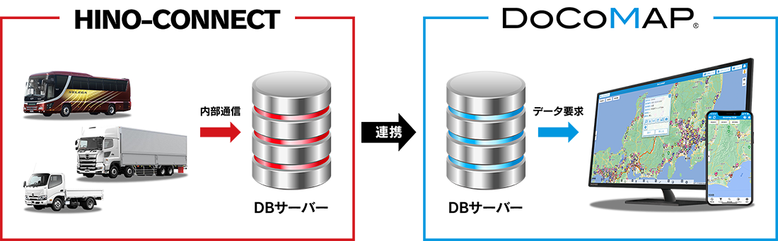
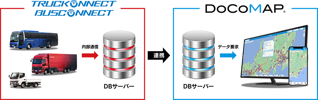
HINO-CONNECT
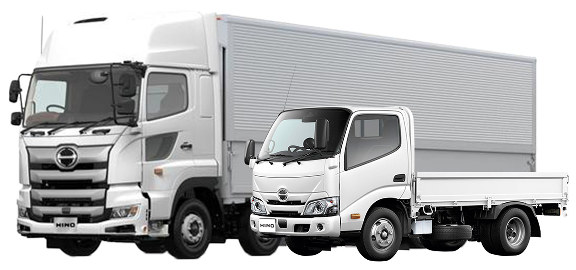
By connecting to applicable Hino Motors vehicles, you can use DoCoMAP services without subscribing to the previously required dedicated DoCoMAP GPS terminal.
Monthly fee
Basic
1,180
円/台(税込1,298円)
Vehicle management support
Premium
1,480
円/台(税込1,628円)
Vehicle management support + support for SDGS and ESG decarbonization initiatives
Connected Integration
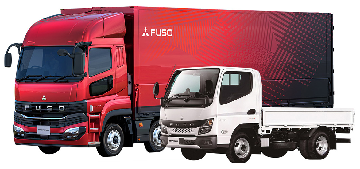
By linking with supported Mitsubishi Fuso vehicles, you can use the DoCoMAP service without having to rent a docomap DoCoMAP GPS device.
Monthly fee
Basic
1,180
円/台(税込1,298円)
Vehicle management support
Green
1,480
円/台(税込1,628円)
Vehicle management support + environmental support
Basic Information
Basic plan
Premium plan


HINO-CONNECT
By connecting to applicable Hino Motors vehicles, you can use DoCoMAP services without subscribing to the previously required dedicated DoCoMAP GPS terminal.
Connection Image
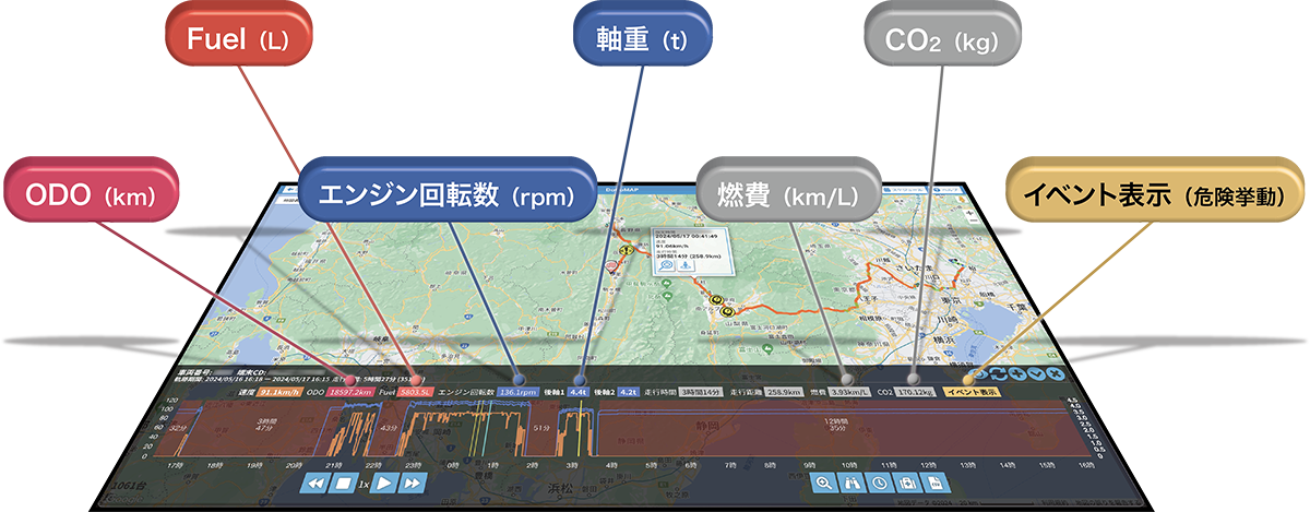
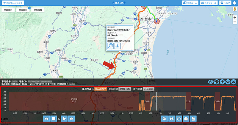
Real-time location information
With DoCoMAP, you can display and manage the position of vehicles on Google Maps. It is also possible to directly use Google Maps functions such as traffic information and street view.
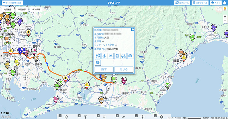
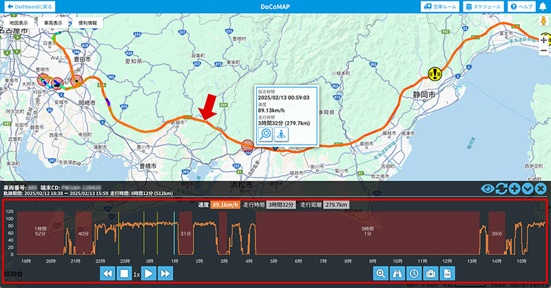
Vehicle route tracking
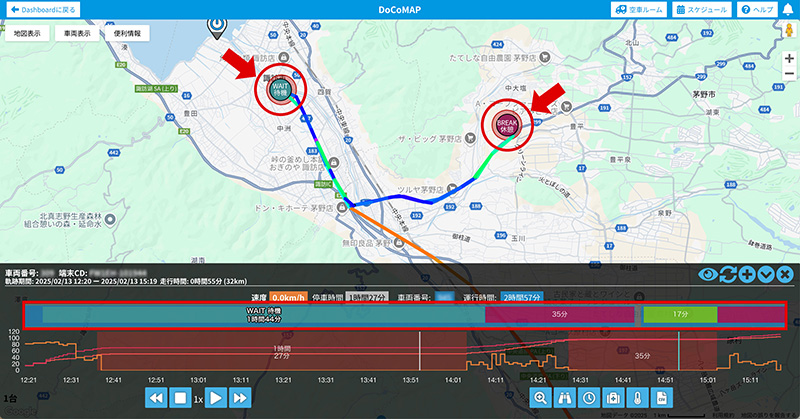
You can easily check the route history of vehicles by simply clicking the vehicle icon. Apart from being able to check the speed of vehicles on the graph, it’s also possible to confirm continuous driving time and therefore manage the required break time of drivers.
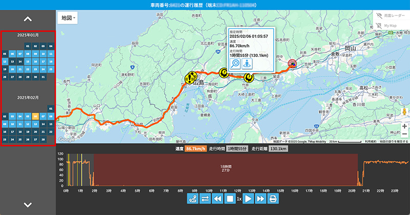
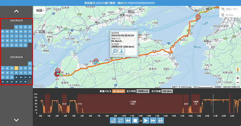
13 months of vehicle tracking data
While displaying the trajectory of a vehicle on the map, you can also show a graph linked with speed and time when viewing past routes of a vehicle, which can be easily accessed from the calendar.
Supports docomap PLUS
docomap PLUS is an application for smartphones that enables real-time recording and management of vehicle operations which is linked to vehicle location information in the cloud through DoCoMAP.
Dangerous Driving Behavior Detection
Users can check in real time the operating status of safety devices such as Driver Monitor Warning Information and Collision Avoidance Assistance with Pedestrian Detection, which have contributed to raising driver awareness of safe driving.
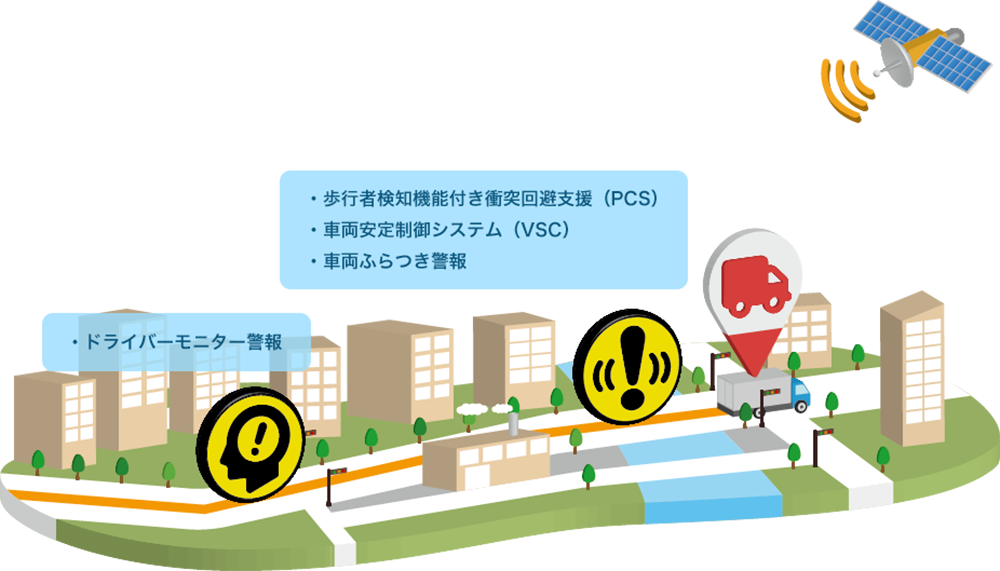
Driver Monitor Alert
The monitor camera constantly checks the driver's posture, direction, and eyelid opening/closing status. It alerts the driver if it detects a lack of attention to the road ahead. The camera is located in a place where the face is easily recognized, leading to improved detection. This helps prevent accidents due to inattention.
*Under certain conditions, the driver monitor may not be able to judge the driver's driving posture, face direction and eyelid opening/closing correctly and the warning function may not operate correctly.
Vehicle Sway Alert
When driving at speeds of approximately 60 km/h or more, if the steering angle sensor detects an increase in steering wheel wobble, an alarm is triggered and the driver is urged to take a rest. If the alarm continues, the PCS is activated faster.
*May not be activated depending on road conditions, vehicle condition, or weather conditions.
Collision Avoidance Assist with Pedestrian Detection (PCS)
It reduces the speed at the time of collision to help mitigate collision damage. Millimeter-wave radar and image sensor enable detection of stationary pedestrians in addition to stationary vehicles, contributing to the reduction of collisions.
*Depending on road conditions, vehicle and weather conditions, and the driver's operation, the PCS may not be activated, may be activated in situations other than collision, or may be delayed.
*PCS is a registered trademark of Toyota Motor Corporation.
Vehicle Stability Control System (VSC)
If a vehicle veers out of its lane, rolls over, slips on the road, or spins, the system supports hazard avoidance by sounding an alarm, controlling engine output, and braking.
*VSC may not be activated or may not be fully effective if the vehicle speed exceeds the VSC control limit, if the vehicle is loaded improperly, or depending on road and weather conditions.
*VSC is a registered trademark of Toyota Motor Corporation.
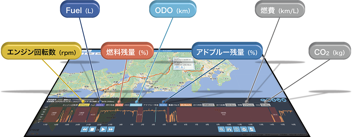
CO2 emissions and fuel consumption
To support efforts in addressing environmental issues, the system includes a feature that visualizes CO2 emissions and fuel consumption. By using this feature, users can manage energy use and environmental impact in transportation operations, contributing to the realization of a decarbonized society.
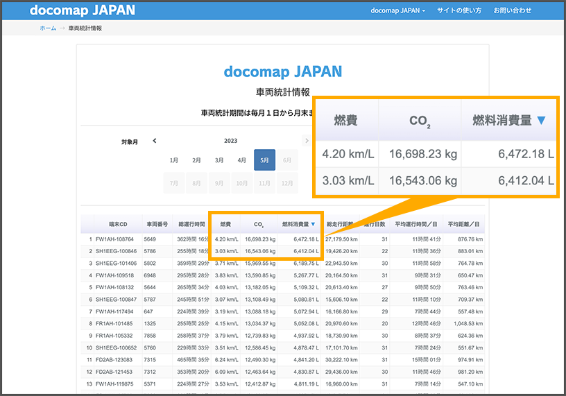
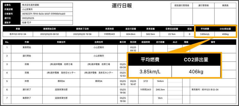
Based on the information obtained from HINO-CONNECT, you can view fuel consumption and CO2 emissions data in DoCoMAP as well as in generated operation reports, providing support for companies working to address environmental issues.
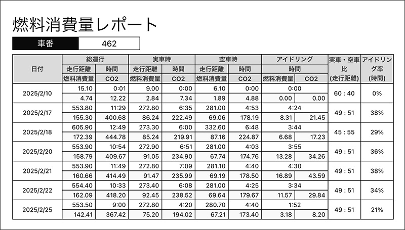
Fuel Consumption Report Output
Fuel consumption can be checked for when the vehicle is loaded, unloaded, or idling. The system can also automatically generate reports on the ratio of loaded to unloaded operations, as well as idling rates.


docomap JAPAN ・ Customer Support
03-6809-2105
Business hours 9:00 ~ 18:00 (Except weekends and holidays)