docomap
Longrange
Long-term location management with ELTRES™ IoT network services
ELTRES™ Asset Tracker

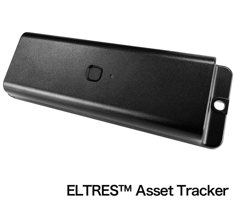
The ELTRES Asset Tracker is linked to DoCoMAP, using features of the Eltres™ IoT Network Service, Sony Group's LPWA (Low Power Wide Area) communication standard, which features long-distance stable communication, high-speed mobile support, and low power consumption. Location information can be checked on DoCoMAP once every four hours for up to four years simply by attaching the device to the vehicle.
*Due to low inventory, we are currently not accepting new orders.
Base Price:
Open
Monthly fee:
980
円/台(税込1,078円)


ELTRES™ Asset Tracker
The ELTRES Asset Tracker is linked to DoCoMAP, using features of the Eltres™ IoT Network Service, Sony Group's LPWA (Low Power Wide Area) communication standard, which features long-distance stable communication, high-speed mobile support, and low power consumption. Location information can be checked on DoCoMAP once every four hours for up to four years simply by attaching the device to the vehicle.
* ELTRES™ IoT Network Service is an LPWA (Low Power Wide Area) wireless communication standard for use in IoT networks, developed by combining various technologies that Sony has developed.
* Location data is collected once every 4 hours, allowing up to 4 years of use. However, you can select other intervals, such as once every hour for 1 year, every 2 hours for 2 years, every 3 hours for 3 years, or every 6 hours for 6 years. The battery operating time may be affected by the ambient environment.
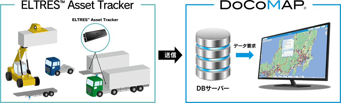
Connection Image
| Size | W65 × D34 × H200 (Including mounting area) |
| Weight | About 330g |
| Internal sensor | GNSS (GPS/GLONASS/QZSS], 3-axis acceleration sensor |
| External interface | Bluetooth |
| FW Update | Bluetooth |
| Communication system | LPWA |
| Battery | Lithium primary battery |
| Operating environment temperature | -20℃ to 60℃ |
| Water/dust resistance | IP67 |
ELTRES™ loT Network Service advantages
ELTRES™ loT Network Service offers long-distance performance of 100 km or more and support for communications from moving vehicles at speeds of 100 km/h or more, as well as highly sensitive and stable communications even in urban areas.
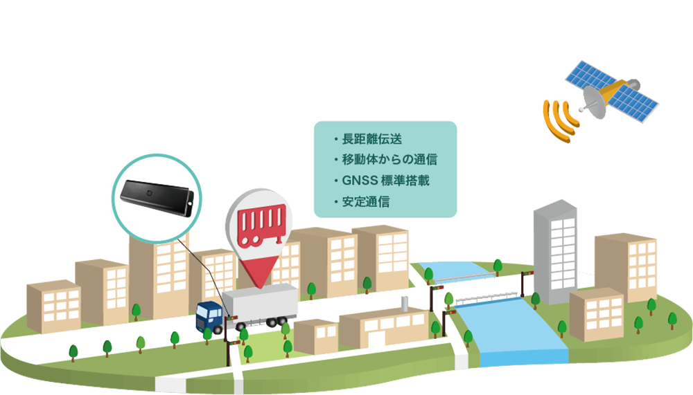
Transmission from moving objects
Compatible with moving objects traveling at speeds of 100 km/h or more.
* Other companies' LPWA cannot acquire data such as location information due to data attenuation on moving objects traveling at speeds of 40 km/h or more.
Stable communication
Highly sensitive communication even in urban areas.
* Through waveform synthesis, LDPC error correction, multi-channel usage, and handover, stable communication is possible.
Long-distance transmission
Transmission performance of 100 km or more in line-of-sight.
* Other domestic companies' LPWA radio wave transmission is limited to 20 km.
GNSS standard
Can obtain latitude and longitude (compatible with Quasi-Zenith Satellite MICHIBIKI).
Location information
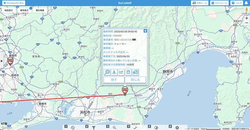
DoCoMAP can display and manage vehicle locations on Google Maps. Using Google Maps' functionality, users can also directly access features such as traffic congestion information and Street View.
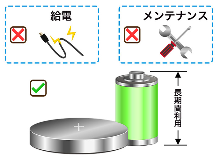
4-year battery life
Although it is a battery-less device, it acquires location information every 4 hours. It can be attached to a solid object for 4 years without a power supply, eliminating the need for maintenance, power supply, etc.
docomap JAPAN ・ Customer Support
03-6809-2105
Business hours 9:00 ~ 18:00 (Except weekends and holidays)